Harbour Notice 03-2026
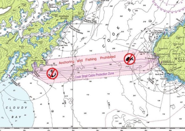
Seaworks are undertaking a survey operation in Cook Strait for Transpower New Zealand. During operations, survey vessel Seasurveyor will have a tow-fish deployed near the seabed and will be operating as Restricted Ability to Manoeuvre (RAM). The tow fish will generally be deployed to the seabed, however may be up to 1,000m behind the main survey vessel.
A Coastal Navigation Warning will be in place with RCCNZ. To note, this is not the regular annual Seaworks survey, and the vessel will be running survey ‘lines’ across Cook Strait in a regular pattern covering a significant area within the cable protection zone. Cook Strait vessel traffic can contact Seasurveyor at any time to confirm our intended survey route and/or turning locations etc.
- Vessel contact: Seasurveyor / ZMG2418
- 24-hour/day operations
- Seasurveyor will be R.A.M during operations
- Commencement in Cook Strait 15 Jan 2026
- Expected duration – east/west survey lines: 25 days
- Expected duration – north/south survey lines: 15 days
- Vessel Speed: 4.5kts
- AREA COOK
- SURVEY IN PROGRESS BY MV SEASURVEYOR IN AREA BOUNDED BY:
A. 41-18.40S 174-14.30E
B. 41 15.90S 174-35.80E
C. 41-20.10S 174-39.20E
D. 41-22.50S 174-10.00E